This PDF file is a photocopy of the first 28 pages of Ruth's transcription. http://www.mykennebunks.com/Archives/Town Book 1 comp.pdf
Proprietor's Book 1725/26 to 1784
The Proprietor's Book is in pretty rough shape. The Kennebunkport Historical Society has the original but it belongs to the town. They also have a printed copy and microfilm that Julian Howard had made when he was President of the Society. The Town Clerk has a copy and there are at least one or two other copies floating around. KHS does not have a microfilm reader but the Kennebunk Library does.
This PDF file is a photo copy of one of the printed copies. http://www.mykennebunks.com/Archives/Proprietors Book to Page 23.pdf
Book of Eastern Claims
After the Indians attacked Cape Porpoise and drove the settlers away in 1689, all but a few pages of the Town Book were lost and many of the settlers had in their haste to leave town, left their deeds and family documents behind. This was the case for many Maine towns after King Phillips War and King William's war. When the settlers began returning to their homes or the homes of their ancestors they were required to prove land ownership. Once they had argued to the satisfaction of the officials the trail of ownership was entered into this book created about 1700 and thenceforth it was accepted as proof. The original documents are at The Massachusetts Archives.
This is a transcription of the Eastern Claims for Cape Porpoise and Winter Harbor, published in the Maine Historical Genealogical Recorder in 1887. http://www.mykennebunks.com/Archives/Eastern Claims.pdf
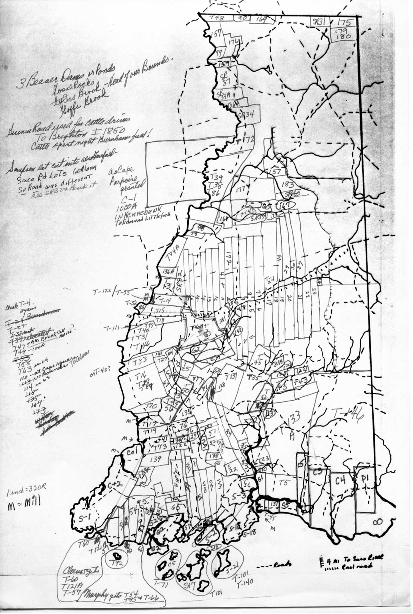
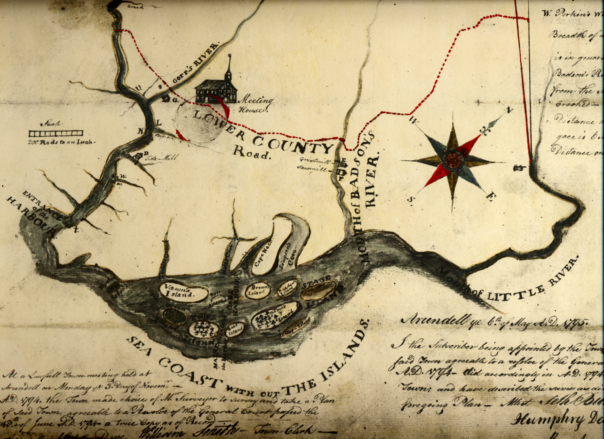
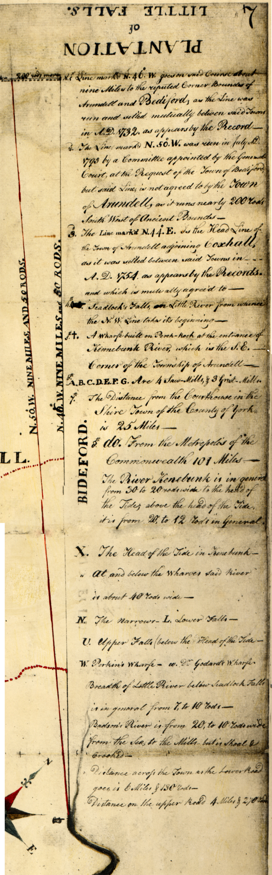
1795 Seth Burnham Map
At a lawful Town Meeting held at Arundell on Monday ye 3rd day of November A.D. 1794 the town made choice of Mr. Surveyor to survey and take a Plan of said town agreeable to a Resolve of the General Court passed the 18th of June A.D. 1794 - A true copy as of Record- William Smith - Town Clerk Signed by Seth Burnham and others and filed at the Registry
This is a photograph of a portion of the map. One original is at the Historical Society but belongs to the Town.
Map http://www.mykennebunks.com/Archives/1795 Seth Burnham map.jpg
Legend http://www.mykennebunks.com/Archives/1795 map legend.jpg
Other Maps
See 1856, 1872 and 1890 maps here http://www.mykennebunks.com/maps.htm
An 1899 Survey map of Cape Porpoise Harbor http://www.mykennebunks.com/Goat%20Island/Jan-9,-1899-Survey-CP-Harbo.jpg
1845 Goat Island Light Complaint
The Congressional report of Adam McCulloch's complaint against the Government for unlawfully taking possession of Goat Island for the lighthouse is interesting because in it several people testify about who was living on which island, when. Charles Bradbury, the very historian who first wrote that the Indian Attack on Fort Island occurred in the year 1690, testifies in this document that Cape Porpus was depopulated in 1689. Further evidence that the date of 1690 that has been quoted by every historian since, was a typo all along.
http://www.mykennebunks.com/Goat%20Island/Ownership%20of%20Islands.pdf
For more on Goat Island see http://www.mykennebunks.com/lighthouse.htm and http://www.mykennebunks.com/revolution.htm
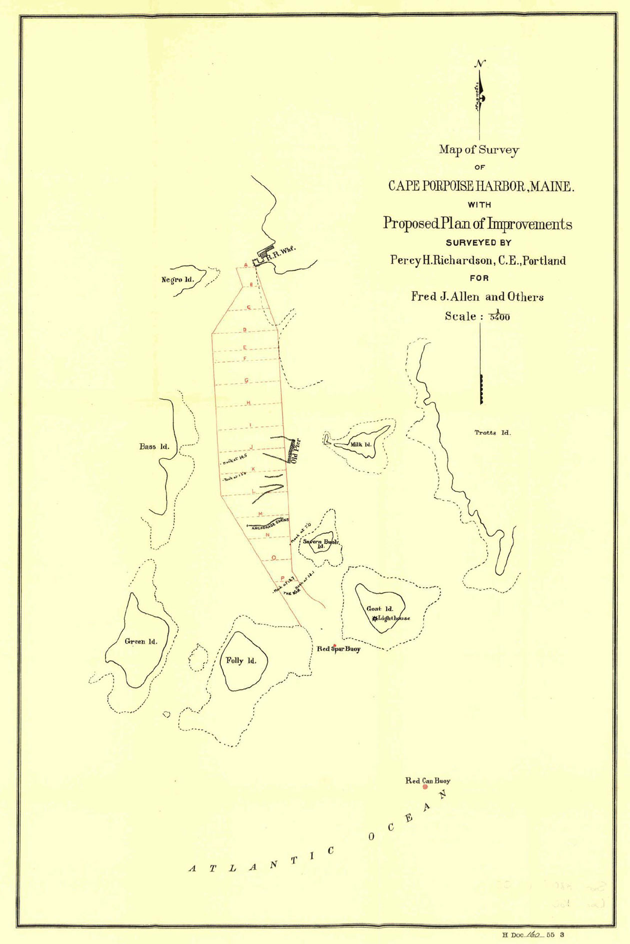
1844 Harbor Improvement Proposal
A proposal for improvements to Cape Porpoise Harbor was made by Congressman Joshua Herrick to the Secretary of War in 1844. The proposal is interesting because it refers to a plan made of Cape Porpoise Harbor and discusses granite quarry opportunities nearby. I have not found the plan but someone did. I have seen a copy of a sketch that shows the 852 ft pier. It is marked copied by Adelaide day. The writing on it was Joyce's handwriting. It showed Huff's Store, Huff's Wharves and fish houses, P Stone's wharf and fish house, J. Stone's wharf and fish house, stone bridge, Bickford Island with buildings and wharf, Negro, Buss, Green, Folly, Milk, Savin Bush, Goat, Trott's, Cape, and Redding Islands. It also shows the proposed 852' long pier. I continue to search the plan files in Alfred.
http://www.mykennebunks.com/Goat%20Island/harbor%20survey%20pier.pdf
 Search
the very earliest York County Deeds here
York County Deeds .
The secret to good searching is in how you place " marks. For recent deeds, set up a free account at the York County Registry of
Deeds here
http://www.york.me.us.landata.com/
and search their database. To see deeds in between you will have to
visit the courthouse in Alfred, Maine. It is worth the trip though, as
York County Probate records are kept
there as well. For current
information about home ownership and address use the Vision Appraisal
Database here
http://www.visionappraisal.com/databases/
Search
the very earliest York County Deeds here
York County Deeds .
The secret to good searching is in how you place " marks. For recent deeds, set up a free account at the York County Registry of
Deeds here
http://www.york.me.us.landata.com/
and search their database. To see deeds in between you will have to
visit the courthouse in Alfred, Maine. It is worth the trip though, as
York County Probate records are kept
there as well. For current
information about home ownership and address use the Vision Appraisal
Database here
http://www.visionappraisal.com/databases/
Collections, Documentary History, etc. of the maine historical society are full of historical information about York County. You will even find the elusive Volume I. It includes Political Affairs of the Province , An Account of Wells , and Extracts from Early Court Records of the Province of Maine. The early court records are very helpful because the six volume set of Maine Province and Court Records, published by the Maine Historical Society are not yet online. The books are in the reference room at the Kennebunk Library but cannot be checked out.
Collections of and Proceedings of the massachusetts historical society also contain a wealth of information about York County as it was part of Massachusetts 1653 through 1820 with a few early gaps due to territorial battles in England.
Two really good Gbooks that describe everyday life in Colonial New England are Social Life in Old New England by Mary Caroline Crawford http://www.google.com/books?id=RrLBiM9H-acC&printsec=frontcover&dq=label:%22colonization%22&lr=
and The Customs of New England by Joseph Barlow Felt http://www.google.com/books?id=tizU6dsA2p8C&printsec=frontcover&dq=label:%22colonization%22&lr=
Early issues of New England Historical Genealogical Register are on Google Books at nehgr
The Rising Sun - A newspaper published of school grounds in 1971 when a Kennebunk High School Student's editorial piece was censored out of the school newspaper.
Kennebunk enlistments in the Civil War
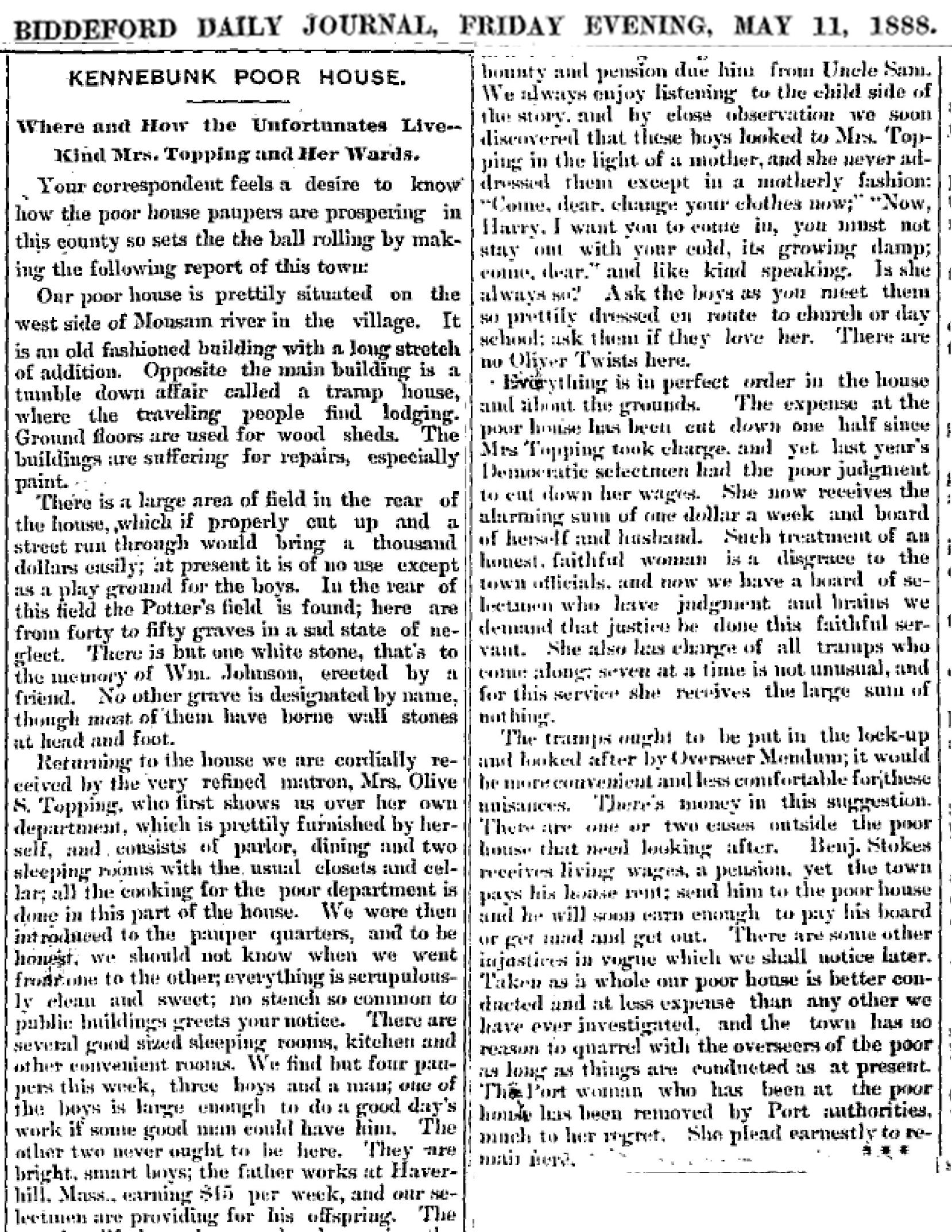
Kennebunk Poor Farm from Biddeford Daily Journal 1888
North Kennebunkport and Arundel Town Reports in searchable PDF files
Revolving Links and Current Projects
Stage Island Fort Shipbuilding Cape Arundel
Tips on York County historical and genealogical research
Published Articles Old News Columns - on separate page
Kennebunkport Historical Society Log
Wells Sanitarium was the Pitts
Priest Shoots Photographer Out of North Kennebunkport Sky
Patriots Day 1775 news report of the action at Lexington & Concord New Hampshire 4-21-1775